


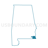
Lovetown, Houston County, Alabama
About
Outline

Summary
| Unique Area Identifier | 521938 |
| Name | Lovetown |
| County | Houston County |
| State | Alabama |
| Area (square miles) | 7.99 |
| Land Area (square miles) | 7.96 |
| Water Area (square miles) | 0.04 |
| % of Land Area | 99.52 |
| % of Water Area | 0.48 |
| Latitude of the Internal Point | 31.11138850 |
| Longtitude of the Internal Point | -85.29570850 |
Maps

Graphs
Select a template below for downloading or customizing gragh for Lovetown, Houston County, Alabama


Neighbors
Neighoring Voting District (by Name) Neighboring Voting District on the Map
- Cotton Wood, Houston County, AL
- Dupree, Houston County, AL
- Enterprise Church, Houston County, AL
- Hodgesville, Houston County, AL